The Tunisian VMS: A National Experience in Satellite Fisheries Monitoring, Technological Mastery and Data Sovereignty

Share
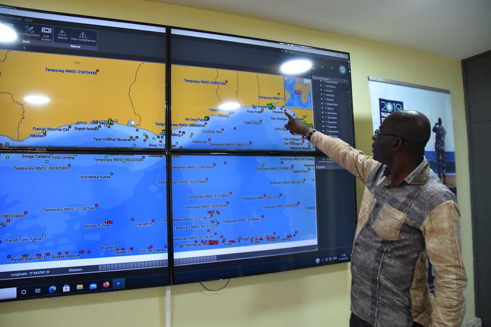
As the former project manager of Tunisia’s satellite vessel tracking system (SSN/VMS), I present here the national experience I led, from the first trials in 2003 to coverage of 874 vessels in 2025. The system combines onboard equipment, INMARSAT-C communication, a national reception and processing centre (the CAGIP), a nationally developed mapping application (GIS-WEB) and a PostgreSQL/PostGIS database hosted on ministry premises.
This combination shows that a State can use an international satellite operator while keeping control of its data: encrypted on board, the data are decrypted only on the CAGIP servers. I draw lessons for African States strengthening their fisheries monitoring, setting them alongside other regional experiences (Morocco, FCWC, SADC, Indian Ocean).
1. Introduction: VMS as an instrument of fisheries governance
Sustainable management of living marine resources depends on States’ ability to know, track and control the activities carried out in the maritime areas under their national jurisdiction. This requirement has become particularly important in the face of growing pressure on fish stocks, the intensification of fishing activity and the complexity of surveillance operations at sea.
Fisheries administrations need reliable information on authorised vessels, their movements, the areas they frequent and the activities they carry out. They must also be able to detect situations that may constitute breaches of national or international regulations.
In this context, the satellite vessel monitoring system, or VMS (Vessel Monitoring System, known as SSN in Tunisia), is an important tool within the fisheries monitoring, control and surveillance arrangements generally grouped under the term MCS.
A VMS relies on the periodic transmission of position data from equipment installed on board vessels. This information is received and processed by a ground infrastructure that lets the competent administrations view the movements of fishing units and analyse their activities.
However, reducing the VMS to a simple map of vessel positions would be a limited view of its possibilities. When combined with structured databases, regulatory information, mapping tools and suitable administrative procedures, it becomes a genuine information system for fisheries management. Its value therefore goes beyond tracking movements. It helps in particular to:
- verify compliance with authorised fishing zones;
- monitor the movements of vessels subject to tracking requirements;
- identify behaviours or situations that call for verification;
- improve spatial knowledge of fishing effort;
- facilitate coordination between administrative services and monitoring centres;
- contribute to maritime safety and the handling of distress situations;
- produce information useful for planning and managing fish resources.
In this respect, the Tunisian experience is an interesting example of developing a national satellite monitoring architecture that combines international communication technologies with IT tools adapted to the needs of the fisheries administration.
This article is an account by a participant, not an independent evaluation. What I report on the Tunisian system comes from my own practice and from my presentation at the workshop of the General Fisheries Commission for the Mediterranean (GFCM) in Zagreb in 2011; for other countries, I rely on public sources cited in the references.
2. Origins and development of the Tunisian system
During the 2000s, the Tunisian administration wanted a means of tracking fishing vessels remotely, of obtaining geographic information on their movements, and of facilitating intervention by the surveillance and rescue services. I led the project, which drew on national skills to design the architecture, integrate the communication equipment and develop the operating applications. It was built in stages:
| Period | Stage |
| 2003–2006 | Trials of solutions based on the national GSM network and the Thuraya satellite, starting in 2003 with six vessels. |
| 2007–2008 | Pilot phase with tuna vessels: 20 units at the outset, then 54. |
| November 2011 | Presentation of the Tunisian experience at the GFCM VMS workshop, Zagreb, 28–30 November. |
| 2013 | About 60 vessels tracked. |
| 2013–2025 | Coverage grew to 874 vessels. |
In January 2021, a ministerial announcement relayed by the TAP news agency presented the activation of the national system, developed and hosted within the ministry, with 50 central and regional control rooms and equipment planned for 874 vessels over 15 metres, accompanied by incentive measures to help cover operating and maintenance costs.
3. Technical architecture
The architecture combines four interdependent components: onboard equipment, the satellite communication chain, the national reception centre, and the control and rescue centres.
3.1. Onboard equipment
On board, the system relies on two elements: the Thrane & Thrane TT3026D unit, which acts as the antenna, and a U3C terminal installed on the bridge, at the captain’s disposal, developed by the Tunisian company SEIS. Together with GPS positioning and INMARSAT-C communication, they provide:
- acquisition and transmission of positions;
- reception of messages from shore centres and their consultation by the captain;
- transmission of reports on fishing activity;
- triggering of distress messages;
- reporting of certain technical anomalies.
The system includes a dual-contact distress circuit and a backup power supply whose specification announces up to one week of autonomy. This is a technical specification, not a performance verified on all installations. From the 2004 specifications onward, the system also provided for detection of tampering attempts, remote administration, and data compression and encryption.
3.2. The INMARSAT-C communication chain
The functional chain is as follows: fishing vessel → U3C/TT3026D equipment and GPS → INMARSAT-C network → Land Earth Station (LES) → secure public network → CAGIP.
Communication was two-way. Vessels could transmit positions, reports and alerts, and also receive messages sent by shore operators. Exchanges could notably cover:
- periodic position reports;
- fishing trip reports;
- catch information;
- distress messages;
- free messages between the vessel and operators;
- weather information available on request.
The system made it possible to set the position transmission frequency, remotely or according to preset parameters.
INMARSAT-C transmits messages and data in packets. It should not be equated with a permanent real-time data stream comparable to a continuous Internet connection. Tracking relies on the regular receipt of position reports, whose frequency depends on configuration parameters and communication conditions. This distinction matters for correctly interpreting trajectories and any periods without reception.
3.3. The CAGIP: the national centre for receiving and managing information
The CAGIP (Centre d’Administration et de Gestion des Informations de la Pêche, the Fisheries Information Administration and Management Centre) was the central element of the national architecture. It received and managed the information coming from vessels, processed it, and made it available to the structures responsible for fisheries surveillance and management.
The 2011 technical presentation distinguishes several IT functions within this architecture:
- CAGIP central server;
- CAGIP messaging server;
- messaging server for the control and rescue centres;
- historical alerts database;
- historical vessels database;
- mapping server;
- operator workstations;
- administration workstation;
- system administration functions.
This organisation reflects a functional separation between message reception, history keeping, map display and administrative use. The system was therefore not limited to receiving vessel coordinates: it structured information around several categories of data and operational functions.
3.4. Control and rescue centres
The architecture also provided for control and rescue centres, designated CSC in the technical documents. These structures received and processed alerts, notably distress messages. The distinction between the national CAGIP and the CSCs made it possible to organise central management functions separately from surveillance and intervention operations.
This organisation is particularly important for marine fisheries, because vessel monitoring is not only a matter of regulatory control: it also has a dimension of safety of people and property at sea.
4. GIS-WEB and PostgreSQL/PostGIS: a nationally developed geospatial architecture
The geographic IT component is one of the distinctive features of the Tunisian system. The GIS-WEB application came from a specific national development. Its purpose was to give users a mapping interface for viewing and using vessel position data, information on regulated zones and the other geographic layers needed for fisheries management. The database relied on PostgreSQL, combined with its PostGIS spatial extension. This choice made it possible to combine the management of conventional administrative and descriptive data with that of geographic objects.
4.1. PostgreSQL: relational data management
PostgreSQL served as the relational database management system. It organised information on vessels, positions, alerts, fishing trips, catches and the other elements needed to run the system. Relational organisation offers several advantages:
- structuring of information around identifiers and relationships between tables;
- retention of historical records;
- possibility of complex searches and queries;
- consistency between administrative data and operational information;
- possibility of gradual evolution of the database according to the administration’s needs.
4.2. PostGIS: spatial data management and analysis
The PostGIS extension made it possible to manage geographic information directly in the PostgreSQL database. This component was particularly important for a vessel monitoring system, since position data must be interpreted in their spatial context. Geographic data could cover in particular:
- successive vessel coordinates;
- the limits of maritime areas;
- territorial waters;
- prohibited or regulated zones;
- isobaths and bathymetric data;
- anchorage zones;
- fishing zones;
- trajectories and areas frequented.
The PostgreSQL/PostGIS combination thus made it possible to compare vessel positions with regulatory and geographic information. For example, a received position could be analysed according to its location relative to a prohibited zone, a regulatory boundary or a defined fishing zone. This capability is one of the technical foundations of spatial monitoring of fishing activity.
A distinction must nevertheless be drawn between the technical ability to run a spatial query and the legal characterisation of an offence: a geographic alert is an element that calls for analysis and, where appropriate, further verification.
4.3. GIS-WEB: a purpose-built business application
The national development of GIS-WEB provided an interface adapted to users’ needs and to the specificities of Tunisian regulations. The application provided in particular map display of vessels and of the geographic layers needed to monitor them. The documented functions included:
- display of the reference map;
- display of tracked vessels;
- consultation of received positions;
- representation of trajectories;
- consultation of history;
- display of alerts and special statuses;
- overlay of regulatory and geographic layers;
- access to information useful for administrative management.
The system also includes a geographic database covering territorial limits, isobaths, zones prohibited according to fishing methods, fishing campaign areas and trawler anchorage zones.
It is important to stress that GIS-WEB should not be presented as commercial GIS software simply installed and configured. It was an application developed specifically to meet the needs of the Tunisian system. This approach reflects a desire for a national business tool able to evolve with the administration’s requirements and the specificities of fisheries regulations.
5. Operations and applications of the VMS
The value of a VMS is measured mainly by its ability to turn position data into information useful for managing and controlling fisheries. The Tunisian experience shows several operational applications.
5.1. Tracking movements and reconstructing trajectories
The system’s first function is to let operators consult the successive positions of vessels and reconstruct their trajectories. This gives better visibility of fishing units’ movements, the areas they frequent and the routes they take. Archiving positions also makes it possible to consult past activity and carry out analyses over different periods. This information is particularly useful for verifying a vessel’s presence in a given area, analysing its movements and examining the circumstances of a reported event.
5.2. Analysing fishing activity
Vessel trajectories and speeds can provide indications of the different phases of a fishing operation. For trawlers, variations in speed and heading can help identify characteristic sequences:
- transit to the fishing area;
- start of a fishing operation;
- trawling phase;
- change of direction;
- hauling of the gear;
- return to port.
Analysing this information improves knowledge of fishing activity and can complement vessels’ declarations. It must nevertheless be remembered that the VMS is not, on its own, automatic proof of a vessel’s actual activity. Interpretation of trajectories must take into account the type of fishing, the vessel’s characteristics, weather conditions and other available information.
5.3. Monitoring regulated zones
Integrating positions into a geographic information system makes it possible to compare them with the boundaries of regulated zones. The system can thus help flag situations such as:
- a vessel’s presence in a zone where its activity is prohibited;
- entry into a restricted zone;
- repeated visits to sensitive areas;
- movements requiring administrative verification.
These functions strengthen administrations’ monitoring capacity and help direct control operations towards situations of particular interest.
5.4. Maritime safety and distress
The system also included a function for transmitting distress messages. This function created a direct link between the onboard equipment and the shore structures responsible for receiving and handling alerts. Two-way communication also allowed operators to send messages to vessels. The VMS thus served a dual purpose: an instrument for monitoring fishing activity and a complementary means of communication and maritime safety.
5.5. Weather information and communication with fishers
The system also makes it possible to receive weather forecasts on request. The information provided covered in particular wind speed and sea surface temperature, with two-day forecasts at six-hour intervals. This feature illustrates how a monitoring system can evolve into a platform of services and information for users on board. It also shows that satellite communication technologies can be put to use beyond the mere transmission of positions.
6. Access management, security and data confidentiality
Information security is a fundamental dimension of any satellite monitoring system. VMS data are sensitive: they reveal vessels’ movements, the areas they frequent and, indirectly, the economic organisation of fishing operations. The Tunisian system separates consultation interfaces from administration interfaces and distinguishes several categories of users: system administrators, CAGIP operators, CSC operators, fisheries administration services and users on board.
The transmitted data are encrypted; they are decrypted only on the CAGIP servers. The intermediaries in the transmission chain therefore handle only encrypted data, and reading the information remains the administration’s prerogative.
Any system of this type should also provide for individual authentication, separate rights for consultation and modification, logging of sensitive operations, tested backups, and control of external providers’ access. These principles are all the more important when a State entrusts part of the service to private companies.
7. National data sovereignty: a strategic issue
The Tunisian experience sheds light on a central question for fisheries governance in Africa: sovereignty over infrastructure, IT systems and data. Using an international satellite network does not mean losing control of one’s system: transmission may depend on an external operator, while reception, processing, storage and use remain under national responsibility. In the Tunisian case, this rests on several choices:
- an architecture designed nationally;
- a national information management centre, the CAGIP;
- an application, GIS-WEB, developed specifically;
- a PostgreSQL/PostGIS database, with histories of vessels and alerts;
- data encrypted and decrypted only on the CAGIP servers;
- a system hosted on ministry premises and operated by the competent national structures.
Sovereignty must nevertheless be assessed along several complementary dimensions:
- Technological sovereignty: the ability to design, adapt and develop applications and infrastructure.
- Informational sovereignty: control over the organisation, storage, retention and use of data.
- Operational sovereignty: the ability of national authorities to use information to make independent decisions.
- Institutional sovereignty: control over access rules, responsibilities and the conditions for sharing information.
This distinction avoids a simplistic interpretation of sovereignty, which would hold that using a foreign satellite operator automatically entails a loss of national control. The essential issue is to ensure that strategic data on fishing activities remain accessible to the competent national authorities, under rules defined by the State.
8. Evolution of the Tunisian system and the place of private providers
The Tunisian system rests on a clear division of roles: the administration designs the architecture, hosts and operates the data, while national providers supply components, such as the company SEIS for the U3C terminal. The 2021 ministerial announcement confirms this orientation: a computer system developed and hosted within the ministry, backed by 50 central and regional control rooms, with equipment planned for 874 vessels over 15 metres.
A preparatory study by JICA, based on a 2019 mission and published in 2020, places the VMS within a broader MCS arrangement: it notes limited at-sea surveillance means and justifies additional investment in patrol vessels. A position system replaces neither inspection nor the means of intervention.
The principle to retain is that delegating technical services must not create a dependency that prevents the administration from controlling its data and its decisions. This requires explicit responsibilities between the State and the provider, maintenance and continuity procedures, and reversibility conditions in case of a change of provider.
9. African experiences: complementary regional models
African experiences cannot be reduced to a single “regional VMS” model. They combine national vessel tracking systems, regional data exchange centres, intelligence networks, joint patrols and port control tools. This distinction is essential: some arrangements do share VMS positions, while others mainly organise operational cooperation or information exchange.
9.1. Morocco: linking VMS, radar, centres and patrol vessels
The Moroccan presentation by Tarik Boufdili and Mohammed Benbari, given in Zagreb in 2011, describes an older institutional trajectory: a law incorporating the VMS in August 1999, an implementing decree in March 2010, an implementing order in April 2011 and an announced entry into force in October 2011. The architecture combined satellite vessel tracking with a ground chain transmitting radar echoes from the Royal Navy to the Agadir centre, correlation between radar and satellite data, four control centres, and the equipping of 15 patrol vessels with mobile centres. The presentation also mentions information sharing with ICCAT. (Boufdili and Benbari, “Moroccan VMS”, paper presented at the Zagreb workshop, 2011.)
For the situation reported at the end of 2011, the presentation counts 1,296 equipped vessels: 339 deep-sea and 957 coastal, of which 1,269 in the Atlantic and 27 in the Mediterranean. It indicates an extension target of about 1,500 vessels. The same presentation lists 16,256 units in the active fleet, of which 14,054 artisanal. The 1,296 devices can be read against two very different denominators, the active fleet as a whole and the deployment target of about 1,500, and neither reading should be taken in isolation: the system then targeted a defined part of the fleet, and small artisanal vessels do not appear as equipped in the table presented. This is a historical snapshot of 2011, not a description of the current system.
The comparative lesson lies less in the number of beacons than in the integration of sources and means of action: satellite data can direct attention, radar can help detect or verify activities, and patrols can establish the facts at sea. But bringing these sources together does not automatically amount to proof of an offence; validation procedures, the competence of the authorities and the chain of custody of evidence remain decisive.
9.2. Gulf of Guinea: the FCWC regional centre and PESCAO cooperation
In the Gulf of Guinea, the Fisheries Committee for the West Central Gulf of Guinea (FCWC/CPCO) has developed a Regional Monitoring, Control and Surveillance Centre (RMCSC), hosted in Tema, Ghana. The centre is supported under the PESCAO programme financed by the European Union. It aims to pool vessel tracking, regional registers of authorised vessels, joint patrols, observer programmes and training. The FCWC states that the centre makes regional capacity available to States without a national VMS and allows better tracking of mobile fleets in the region. Institutional descriptions mention the combination of VMS, AIS and other surveillance information.
The 2018–2023 review published by the European Fisheries Control Agency (EFCA) gives more tangible cooperation indicators: 16 joint control operations supported, 690 inspections, 92 infringements detected, 331 satellite images analysed, 159 hours of aerial surveillance, as well as the establishment of the Tema regional centre and of standard operating procedures. These results relate to PESCAO support to regional bodies and the countries concerned; they should not be attributed exclusively to the VMS or to the FCWC centre alone. The distinction between a control activity, a tracking tool and its specific effect is essential for a serious evaluation.
The FCWC arrangement sits within a broader institutional space in which the Sub-Regional Fisheries Commission (SRFC/CSRP), ECOWAS, ICCAT and national administrations also have roles. The thirteen States targeted by EFCA support to the FCWC and the SRFC should not be confused with the six FCWC member States: Benin, Côte d’Ivoire, Ghana, Liberia, Nigeria and Togo. This layering of scales broadens cooperation, but makes a precise definition of responsibilities, authorisations and exchange protocols all the more necessary.
9.3. Southern Africa: the SADC MCSCC, an architecture being made operational
SADC adopted the Charter establishing the Regional Fisheries Monitoring, Control and Surveillance Coordination Centre (MCSCC) in 2017; it entered into force in April 2023. The centre, planned for Maputo, has a regional coordination mandate. The envisaged services include a regional vessel register, a harmonised VMS facilitating the sharing of national information under agreed protocols, a data portal, coordination of observers and patrols, support for port State measures, legal assistance and capacity building. SADC’s institutional page still describes an operationalisation phase run by an interim management unit. The MCSCC should therefore be presented as a legally established regional framework in the course of implementation, not as a continental network already fully operational.
The SADC logic is interesting because it does not assume that States abandon their national systems in favour of an unlimited central database. The regional VMS is defined as a mechanism for sharing national information under protocols. This formula makes access control and the retention of national responsibility possible, but its effectiveness will depend on common rules actually applied, sufficiently standardised data and lasting human and financial resources. The framework alone guarantees neither interoperability nor coordinated action.
9.4. Western Indian Ocean: intelligence networks and joint patrols
In the Indian Ocean region, FISH-i Africa is an example of cooperation based first on information exchange, networking and analysis of illegal fishing cases, rather than on the creation of a single VMS administered by a regional organisation. The 2024 SADC report presents eight participating countries: Comoros, Kenya, Madagascar, Mauritius, Mozambique, Seychelles, Somalia and Tanzania, and reports more than 40 investigations into illicit and related activities. This is a result of cooperation and information sharing; it should not be equated with 40 infringements detected by VMS.
The same report presents the Indian Ocean Commission’s Regional Fisheries Surveillance Programme as a joint regional surveillance mechanism, with 49 patrols representing 1,228 days, two vessels identified in illegal activity and 120 infringements recorded for the period covered by the publication. This model shows the complementarity between analysis and data exchange on one hand, and the operational presence of control assets on the other. It also shows that a region can achieve MCS results without a single supranational VMS.
9.5. Inland fisheries: adapting monitoring to lakes and small-scale fleets
The 2024 SADC report also reports experiences of boat tracking and registration on lakes in four countries: Malawi, Mozambique, Zambia and Zimbabwe, with installation of tracking units and a reported improvement in monitoring capacity and compliance. This case usefully broadens the discussion beyond marine fisheries. However, the public summary provides neither a detailed technical protocol nor an independent evaluation of the effects. Solutions designed for deep-sea vessels cannot be transposed as they are to lake or artisanal fisheries: cost, communication coverage, power supply, unit size and local governance call for different choices.
10. Critical analysis: what VMS systems prove and do not prove
10.1. Coverage figures are not comparable without a denominator
The Tunisian and Moroccan communications illustrate a frequent problem: “equipped vessels” indicators may refer to the total fleet, the active fleet, vessels subject to an obligation, a size category, a deployment quota or a batch actually installed. For Tunisia, the historical documents mention successively six trial vessels, 20 pilot units, about 54 tuna vessels tracked and, in the 2021 announcement, a programme of 874 vessels over 15 metres. For Morocco, the 1,296 operational units of 2011 are to be compared with the deployment target of about 1,500 or with the whole of the 16,256 fishing units recorded.
10.2. A position is neither a catch nor an established offence
A VMS provides position reports at a set frequency; it does not directly measure the species caught, the quantity landed or the gear used. Trajectories, speeds and stops can guide an analysis or justify a check, but their interpretation depends on the fishing method, the weather, the vessel’s characteristics, the transmission frequency and the quality of the regulatory data. An automated alert is therefore not a legal decision. It must lead to a documented analysis and then, if necessary, to verification at sea, in port or through complementary data. FAO guides present the VMS as a tracking tool within a broader MCS arrangement and stress the importance of procedures, means of intervention and data exchange.
Likewise, the temporary absence of positions does not by itself establish tampering: it may result from a breakdown, a loss of power, insufficient communication coverage, a terminal problem or a deliberate act. Procedures must distinguish between these hypotheses, retain logs and allow an adversarial response. Complementarity with AIS, radar, satellite imagery, fishing logbooks, inspections and landing data reduces the risk of drawing conclusions from an isolated signal.
10.3. A centralised system can pool costs but also create new risks
Regional centres can reduce duplication of equipment and improve monitoring of mobile vessels; the FCWC and SADC experiences make this possibility concrete. However, dependence on a centre, an operator or a provider can create a point of failure, an asymmetry of access or a loss of national know-how. Sustainable pooling therefore requires service agreements, explicit responsibilities, continuity plans, proportionate access rights, access audits and the possibility for each State to recover its data in a usable format.
10.4. The weak link is often institutional and operational
Access to positions is only valuable if a competent authority can interpret the alert, verify it, decide on an intervention and handle the case within a legal framework. The PESCAO review, which combines surveillance, training, inspections, procedures and joint operations, illustrates this integrated chain. The JICA study on Tunisia also stresses that satellite tracking means do not replace inspection and patrol means. The VMS must therefore be evaluated as one component of an MCS system, not as a stand-alone indicator of success.
10.5. Inclusion, proportionality and fishers’ trust
A uniform technical obligation can impose a disproportionate cost on small units, especially if terminals, subscriptions, repairs and battery replacement remain at the owners’ expense. The Tunisian communications, by contrast, emphasise the value of distress, messaging and information-broadcast functions, as well as the importance of financial incentives. An effective policy must clearly define obligations by fleet segment, fund public-safety needs, and avoid surveillance excluding artisanal units from formalisation. The confidentiality of fishing grounds and the separation between safety data, control data and scientific data must also be explained to users.
10.6. Public resources confirm progress but leave gaps
The available documents are often project presentations, institutional press releases or donor reviews. They document architectures, objectives and activities, but less regularly measure the real availability of terminals, continuity of transmissions, the number of confirmed alerts, case-processing times or the effect on fishing pressure. The AU-IBAR report on North Africa (2016) notably pointed to weaknesses in cooperation and data sharing, capacity and funding constraints, and insufficient involvement of artisanal fisheries. These findings are a historical diagnostic baseline, not a current assessment of each country; they justify the publication of up-to-date, independently verifiable indicators.
11. Strategic recommendations for Tunisia and African countries
The Tunisian experience offers several lessons of interest to African States wishing to develop or strengthen their fishing vessel monitoring systems.
11.1. Develop national design capacity
The first lesson concerns the importance of national skills. Designing an architecture adapted to the characteristics of the fleet, the needs of the administration and the specifics of national regulations reduces exclusive dependence on commercial solutions. It is not necessarily a matter of manufacturing all the equipment or developing every technological component locally, but of having skills able to understand, integrate, administer and evolve the system.
11.2. Favour open and scalable architectures
The use of PostgreSQL/PostGIS illustrates the value of open technologies for managing geographic data. These technologies can facilitate interoperability, maintenance, application development and control of data. An open architecture must nevertheless be accompanied by technical skills, sufficient documentation and maintenance procedures to ensure its sustainability.
11.3. Integrate the VMS into a national fisheries information system
The VMS should not operate in isolation. Its information should gradually be linked with data on:
- fishing licences and authorisations;
- vessel characteristics;
- catch declarations;
- landings;
- inspections and controls;
- infringements;
- scientific and biological data;
- management area information;
- fuel subsidies.
This integration would make it possible to move from monitoring based mainly on positions to a more complete fisheries management support system.
11.4. Strengthen processing and analysis capacity
The availability of positions is not enough. Administrations must have staff able to interpret trajectories, analyse behaviour, compare geographic information with regulations and use the results in control procedures. Training operators and technical managers is therefore an essential condition for the system’s effectiveness.
11.5. Develop secure regional cooperation
Marine resources and fishing activities do not stop at administrative borders. Cooperation between African States can improve knowledge of fleet movements, strengthen surveillance of vessels operating in several jurisdictions and help the fight against IUU fishing. Initiatives such as the FCWC regional fisheries monitoring centre and SADC’s regional coordination mechanisms illustrate this direction.
However, regional cooperation must rest on precise rules on the data shared, access conditions, institutional responsibilities and the confidentiality of information. Data sharing must not lead to a loss of national control. On the contrary, it should strengthen States’ collective capacity to protect and sustainably manage their marine resources.
11.6. Define data governance and reversible contracts
Every legal framework or service contract should specify who is responsible for the data, who may consult them, for what purposes, for how long, under what security rules, and how the data can be exported if the provider or platform changes. Minimum requirements should include individual authentication, access profiles, logging, tested backups, incident notification deadlines, controls on subcontractors, and a procedure for returning data and documentation. Sovereignty is not measured by hosting location alone: it is also measured by the administration’s ability to access, understand, use and recover its data.
11.7. Evaluate results, not just the number of beacons
An annual dashboard should distinguish at least: (a) the vessels legally subject to the requirement and those actually equipped, by segment; (b) terminal availability and the share of expected positions actually received; (c) alerts generated, verified, closed without action or having triggered a check; (d) the time between alert, analysis and intervention; (e) the resulting inspections and decisions; (f) distress incidents and response times; (g) the full cost per vessel, including equipment, communications, maintenance, staff and renewal; (h) training, continuity exercises and security audits. Publication should protect sensitive operational information while allowing independent evaluation.
11.8. Adopt phased and inclusive implementation
It is recommended to start with a shared diagnosis of the fleet, the risks, the regulated zones, the means of intervention and the recurring costs. Deployment can then be prioritised according to risks and international obligations, with a pilot evaluated before extension. For artisanal units and inland fisheries, solutions must be proportionate, robust and financially accessible. Fishers’ representatives should be involved in defining useful services, distress procedures, confidentiality rules and fault-reporting arrangements.
11.9. Organise regional cooperation around concrete use cases
The frameworks of the FCWC, the SRFC, SADC and the Indian Ocean Commission should prioritise shared and measurable uses: verification of authorised vessels before licensing, continuity of tracking when moving from one jurisdiction to another, sharing of risk alerts, coordination of port inspections and planning of joint patrols. Each use case should have a protocol specifying the issuing authority, the minimum information, the retention period, the confidentiality level, the response time and lessons learned. Regional trust is built through reciprocity and verifiable governance, not by accumulating data in a centre without rules of use.
12. VMS, AIS and satellite observation: complementary technologies
Another important question concerns the distinction between the different technologies used to monitor maritime activities. The VMS, the AIS (Automatic Identification System) and Earth observation data can all contribute to vessel monitoring, but their purposes and characteristics are not identical.
The VMS is specifically designed for tracking vessels subject to monitoring obligations, notably fishing vessels. It generally relies on dedicated equipment and secure communications. The AIS is mainly intended for navigation safety and collision avoidance. It provides useful information on vessel movements, but cannot be regarded as a universal substitute for the VMS. Satellite observation data, notably synthetic aperture radar (SAR) images, can help detect vessels or maritime activities independently of certain transmissions from onboard equipment. These different sources can be combined in an integrated maritime surveillance arrangement.
For African States, a relevant strategy is therefore to develop complementary systems combining VMS, AIS, satellite observation, inspections at sea and information from fishing declarations.
13. Outlook: towards a new generation of African VMS
Technological developments offer new possibilities for improving fishing vessel monitoring systems. Future architectures could notably integrate:
- hybrid satellite communications;
- terrestrial transmission devices where technically and economically relevant;
- advanced trajectory analysis tools;
- automated geographic alert systems;
- data visualisation and sharing platforms;
- stronger cybersecurity mechanisms;
- tools for spatial analysis of fishing effort;
- interfaces with electronic catch reporting systems.
Artificial intelligence could also help identify unusual behaviour and guide control operations. However, these developments must not make us forget the fundamentals: data quality, equipment reliability, continuity of communications, human skills, the legal framework and institutional capacity.
Building an effective VMS does not rest solely on acquiring satellite terminals. It requires a coherent national strategy, sustained investment and clear data governance. For African countries, the challenge is therefore to build systems adapted to their means, scalable and interoperable, while retaining control of strategic information on their marine resources.
14. Conclusion: maritime sovereignty also depends on mastering data
The experience I led in Tunisia, from the trial with six vessels in 2003 to coverage of 874 vessels in 2025, shows the value of a national approach integrating onboard equipment, satellite communications, central infrastructure, databases and mapping tools. The combination of INMARSAT-C, the CAGIP, GIS-WEB and PostgreSQL/PostGIS, with data encrypted end to end up to servers hosted at the ministry, illustrates an architecture in which international communication technologies serve national information management capacities.
This experience is a reminder that satellite monitoring should not be regarded as a mere operation of locating vessels. It is an instrument of knowledge, control and governance of fishing activities. It also highlights the importance of distinguishing dependence on a communication operator, which may be technically necessary, from national control of data and decisions.
For African States, the fundamental question is therefore not only whether they have VMS terminals, but whether they are able to master processing infrastructure, manage their data, develop their own analytical capacity and use the information produced to make informed decisions. The experiences of the FCWC, SADC, FISH-i Africa and the Indian Ocean Commission show that regional cooperation, information sharing, VMS systems and joint patrols are distinct but complementary levers. Their effectiveness depends on clear sharing rules, lasting resources and national capacities for verification and intervention.
Maritime sovereignty is not limited to delimiting the areas under national jurisdiction. It also rests on the State’s ability to know, monitor, control and make use of information on the activities carried out on its marine resources.
Naoufel Haddad
GS MOSFA
Former Project Manager of Tunisia’s satellite vessel tracking system (SSN/VMS)
Documentary and technical references
Author’s sources and national documents
1. Haddad, N. (2011). “VMS/SSN – L’expérience tunisienne dans la mise en place du système de suivi des navires de pêche” (in French). Presentation prepared for the GFCM workshop on VMS implementation in the Mediterranean and Black Sea, Zagreb, 28–30 November 2011.
2. Direction générale de la pêche et de l’aquaculture – Tunisia (October 2013). “Système de suivi des activités par satellite des navires de pêche en Tunisie” (in French).
3. Boufdili, T. and Benbari, M. (2011). “Moroccan VMS”. Presentation at the Zagreb VMS workshop, 28–30 November 2011.
4. GFCM (2011). Report of the VMS Workshop, Zagreb, 28–30 November 2011.
Institutional and regional resources
5. AU-IBAR (2016). Status of the Fisheries Monitoring, Control and Surveillance Systems in North Africa. Report.
6. WMC with TAP (24 January 2021). “Pêche maritime : Le système national de surveillance par satellite des navires de pêche activé” (in French). Article relaying the ministerial announcement.
7. JICA (2020). Preparatory survey report for the project for construction of fisheries resources management patrol vessels in the Republic of Tunisia.
8. FCWC. “Regional Monitoring, Control and Surveillance Centre”; “Regional MCS Centre”; “Member States”.
9. EFCA (2023). Contribution of the European Fisheries Control Agency to “Improved Regional Fisheries Governance in Western Africa” (PESCAO). 2018–2023 review.
10. SADC. “Regional Fisheries Monitoring, Control and Surveillance Coordination Centre (MCSCC)”. Institutional page.
11. SADC (2024). Protecting our fisheries: Working towards a common future. Regional report.
12. FAO. Fishing operations. 1. Vessel monitoring systems. Technical guidelines.
13. FAO. Checklists and technical guidelines to combat IUU fishing – Volume III: Checklist of MCS systems, operations, procedures and tools.